If this is an after-hours emergency please contact University Police at 605-688-5117.
Monday, March 25, 2024 at 6:30 p.m.
Due to the continued winter storm, the SDSU campus in Brookings will remain closed until noon on Tuesday, March 26, 2024. All administrative offices, events and classes will be closed until noon. Essential employees will report to work as assigned. Please check the Emergency Management status page for additional information. We will continue to monitor the situation overnight and adjust in the morning if necessary. Again the SDSU Brookings campus will reopen at noon, Tuesday, March 26, 2024.
•••••
Sunday, March 24, 2024 at 8 p.m.
The IT Support Desk will be available Monday, March 25, from 8 a.m.-5 p.m.
You can contact them via email at supportdesk@sdstate.edu, submit a ticket at https://help.sdstate.edu, or call 605-688-6776.
•••••
Saturday, March 23, 2024 at 3:30 p.m.
•••••
Sunday’s Food Service Hours
Larson Commons:
- Dining: 9:30 a.m.–12:30 p.m. and 5–7 p.m.
- C-Store: 9 a.m.-10 p.m.
- Erbert and Gerbert’s: 4–7 p.m.
University Student Union:
- Qdoba: 4–8 p.m.
- Slices: 4–8 p.m.
- Mein Bowl: 10:45 a.m.–2 p.m. and 4–8 p.m.
Hanson Hall C-Store: 9 a.m.–8 p.m.
Starbucks: 8 a.m.–2 p.m. (may stay open until 7 p.m.)
Monday’s Food Service Hours
Larson Commons:
- Dining: 7:30 a.m.–8 p.m.
- C-Store: 8 a.m.–10 p.m.
- Erbert and Gerbert’s: 11 a.m.–7 p.m.
University Student Union
- Grill : 7–10 a.m.
- Slices: 11 a.m.–8 p.m.
- Noodles: 11 a.m.–8 p.m.
- Simple Servings: 11 a.m.–2 p.m. and 4–8 p.m.
- Chick-fil-A: 10:45 a.m.–8 p.m.
- Mein Bowl: 10:45 a.m.–2 p.m. and 4-8 p.m.
Hanson Hall C-Store: 8 a.m.–8 p.m.
Starbucks: 8 a.m.–TBD
•••••
Saturday, March 23, 2024 at 2:15 p.m.
Due to the predicted winter storm, the South Dakota State University campus in Brookings will be closed from 7 a.m. Sunday through Monday night. All administrative offices will be closed, and classes and events will be canceled.
Essential employees, per SDSU policy 10:7 and the university’s continuity of operations plan, will report to work as assigned. Please check the Emergency Management status page for additional information.
According to the National Weather Service, Brookings County will be in a winter storm warning from 4 a.m. Sunday to 7 a.m. Tuesday. Blizzard conditions are possible with potential snow accumulations of more than 8 inches and ice accumulations up to one-tenth of an inch possible. Winds could gust as high as 50 mph, causing travel to be difficult or impossible.
Currently, campus is scheduled to resume normal operations on Tuesday. We will continue to monitor the situation and adjust if necessary.
The residence halls will be open, and residence hall desks will be staffed from 4-7 p.m. Sunday and Monday. Community assistants will be available for any needs and provide updates pertaining to residence hall events.
The Miller Wellness Center will be open from 9 a.m.-5 p.m. Sunday and Monday with limited programming, including no access to the pool, climbing wall and group fitness. Students and members are encouraged to check the center’s app for programming updates.
The South Dakota State University Early Learning Center will be closed Sunday and Monday.
Previous Announcements
Winter Storm Warning!
Winter Storm Warning in effect from 8 a.m. Wednesday morning to 9 p.m. this evening.
Heavy snow expected. Total snow accumulations of 4 to 8 inches.
Travel could be very difficult due to low visibility and snow-covered roads. This could impact the evening commute.
Another round of snow is expected Thursday night through Friday afternoon. While confidence remains low (<30%) on location and snowfall amounts with this system, there is currently a high (>70%) probability of a plowable snow of greater than 2 inches across much of the area. Stay tuned for further details later today/tonight.
Slow down and use caution while traveling.
The latest road conditions can be obtained by calling 511 or by going to Safe Travel SD.
Thursday, January 18, 2024 at 9:30 a.m.
Winter Weather Advisory now in effect until 6 a.m. Friday for Brookings County.
Blizzard Warning: Severe winter weather is expected within the next 12 to 36 hours or is occurring — including whiteout conditions. Do not travel. TAKE ACTION.
Winter Storm Warming: Dangerous winter weather is expected within the next 12 to 36 hours or is occurring. Considerable travel problems are expected. TAKE ACTION.
Winter Weather Advisory: Potentially dangerous winter weather is expected within the next 12 to 36 hours or is occurring. Travel difficulties are expected. BE AWARE.
Plan on slippery road conditions. The hazardous conditions could impact the evening commute. The cold wind chills as low as 25 below zero could cause frostbite on exposed skin.
Slow down and use caution while traveling.
The latest road conditions can be obtained by calling 511 or by going to Safe Travel SD.
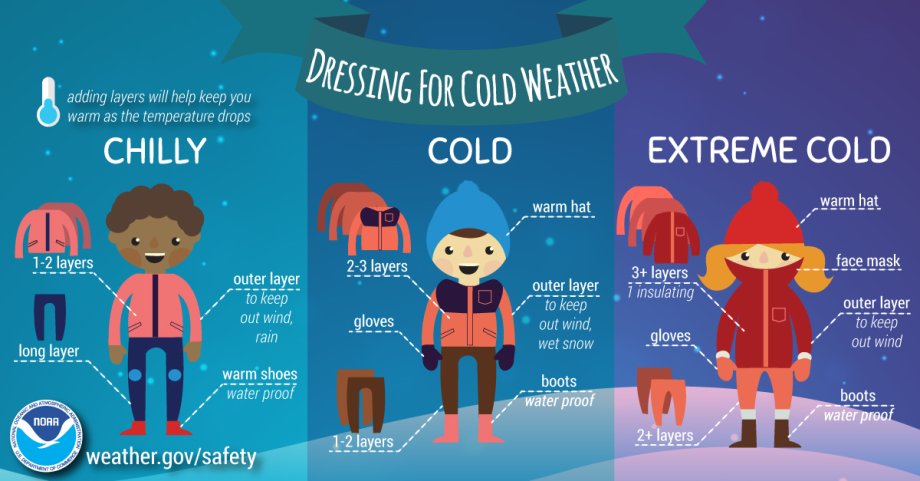
Dressing for cold weather
Adding layers will help keep you warm as the temperature drops
- Chilly
- 1-2 layers - upper body, chest, arms
- Long layer - lower body, waist, legs
- Outer layer - to keep out wind, rain
- Warm shoes - water proof
- Cold
- 2-3 layers - upper body, chest, arms
- Gloves - hands
- 1-2 layers - lower body, waist, legs
- Warm hat - head
- Outer layer - to keep out wind, snow
- Boots - water proof
- Extreme cold
- 3+ layers - upper body, chest, arms
- Gloves - hands
- 2+ layers - lower body, waist, legs
- Warm hat - head
- Face covering
- Outer layer - to keep out wind
- Boots - water proof
Friday, January 12, 2024 at 4:30 p.m.
Due to the forecasted Wind Chill Warning, the MLK Jr. Rally/Marade, scheduled for Monday, Jan. 15 and Tuesday, Jan 16, 2024 has been Postponed.
A new date and location will be determined.
Friday, January 12, 2024 at 9 a.m.
Blizzard Warning in effect from Midnight Friday night to midnight Saturday for Brookings County.
Wind Chill Advisory remains in effect until 6 p.m. Friday.
Wind Chill Warning remains in effect from 6 p.m. Friday to noon on Tuesday.
New snow accumulations up to one inch Saturday.
Plan on slippery road conditions and plan on dangerous road conditions once the blizzard conditions develop. Widespread blowing snow will reduce visibility.
Dangerous cold wind chills could cause frostbite on exposed skin in as little as 10 minutes.
Avoid outside activities. Make sure you wear appropriate clothing, a hat, and gloves.
Travel should be restricted to emergencies only. If you must travel, have a winter survival kit with you. If you get stranded, stay in your vehicle, if it is safe to do so.
The latest road conditions can be obtained by calling 511 or by going to Safe Travel SD.
Thursday, January 11, 2024 at 3:30 p.m.
SDSU Pharmacy in Sioux Falls will be closed on Friday, January 11, 2024 due to weather. Essential personnel Only.
SDSU College of Nursing in Sioux Falls will be closed on Friday, January 12, 2024 due to weather.
SDSU Southeast Farm in Beresford will be closed on Friday, January 12, 2024 due to weather. Essential personnel only.
Sioux Falls Regional Extension Office will be closed on Friday, January 12, 2024 due to weather.
Thursday, January 11, 2024 at 7 a.m.
National Weather Service has issued a Wind Chill Advisory in effect from Midnight tonight to 6 p.m. on Friday (Jan. 12) for City of Brookings.
Wind Chill Advisory means cold weather is expected. Exercise Caution. Dress in layers and cover up exposed skin.
Very cold wind chills expected. As low as -30 degrees.
The cold wind chills could cause frostbite on exposed skin in as little as 30 minutes.
Use caution while traveling outside. Wear appropriate clothing, a hat and gloves.
Dressing for cold weather
Adding layers will help keep you warm as the temperature drops
- Chilly
- 1-2 layers - upper body, chest, arms
- Long layer - lower body, waist, legs
- Outer layer - to keep out wind, rain
- Warm shoes - water proof
- Cold
- 2-3 layers - upper body, chest, arms
- Gloves - hands
- 1-2 layers - lower body, waist, legs
- Warm hat - head
- Outer layer - to keep out wind, snow
- Boots - water proof
- Extreme cold
- 3+ layers - upper body, chest, arms
- Gloves - hands
- 2+ layers - lower body, waist, legs
- Warm hat - head
- Face covering
- Outer layer - to keep out wind
- Boots - water proof
Tuesday, January 9, 2024 at 6:37 a.m.
SDSU -Avera Metro Center in Sioux Falls will have a delayed start today (Jan. 9). They will open at 11 a.m. due to weather conditions in Sioux Falls.
This morning’s elective (CAM, Miller) is canceled. Staff, student and faculty safety remain a top priority. If you feel unsafe commuting to campus, please contact Lisa, your course coordinator, or I to discuss potential alternate arrangements. For those of you parking on campus, please continue to use the East lot; if it is full, backup spots are available at the far east and south of the main lot. Please let Michelle, Lisa or I know if you’ve needed to use overflow parking so we can alert our Avera partners. Please travel safely and allow extra time for your commute.
Monday, January 8, 2024 at 8 p.m.
SDSU College of Nursing - Sioux Falls will have a late start on Tuesday, January 9, 2024 at 10 a.m. due to weather conditions in Sioux Falls.
Monday, January 8, 2024 at 2:14 p.m.
Winter Storm Warning Extended for Brookings County and City of Brookings.
Winter storm warning now in effect until noon on Tuesday, January 9, 2024.
Additional snow accumulation of 2-4". Winds could gust to 30 mph.
Your safety is our very important. Please use caution when traveling. Call your supervisor or adviser if you need to make other arrangements.
The latest road conditions can be obtained by calling 511 or by going to Safe Travel SD.
Brookings to Implement Residential Snow Parking Ban at 8 p.m. today (Monday, Jan 8).
Emergency routes will continue to be cleared during this snow event. The City anticipates plowing residential streets tonight, once the intensity of the winter storm has ceased. Please note that some City streets may be impassable for low-clearance, two-wheel drive vehicles.
This ban does not include the downtown core business district, which is from Third Avenue to Fifth Avenue and from Sixth Street to the railroad tracks. However, vehicles must be removed from streets in the downtown business district between 2 a.m. and 5:30 a.m. daily or be subject to ticketing and towing, per City Ordinance Sec. 82-464. Downtown snow removal is scheduled to start at 2 a.m. Tuesday morning.
Vehicles parked on streets during significant snowfall and high winds create a safety hazard for motorists and for crews working to remove snow.
Citizens should NOT PARK on City emergency routes or residential streets, avenues or alleys. The City asks that citizens remove their vehicles before 8 p.m. today. Violators will be subject to ticketing and towing per City Ordinance 82-465.
More information can be found at Snow Removal Ice Alert Removal Info
Monday, January 8, 2024 at 7 a.m. (Updated 8 a.m.)
Update 8 a.m.:
Mitchell Regional Extension Center is closed today (Jan. 8) due to weather.
SDSU College of Nursing in Sioux Falls offices will be closed to weather.
SDSU College of Nursing site educators will continue with plan for all instruction to move to online-only for Monday, Jan. 8, 2024.
7 a.m.
USD-Sioux Falls campus closed today (Jan. 8) due to the weather conditions.
This alert will close SDSU Pharmacy office and classes in Sioux Falls, Southeast Farm in Beresford, as well as the Sioux Falls Regional Extension Center in Sioux Falls.
College of Nursing in Sioux Falls has moved to online.
Classes will be held and campus will remain open at SDSU campus in Brookings. If you feel unsafe commuting to Brookings Campus, please contact your faculty member and/or supervisor to discuss alternative arrangements.
Sunday, January 7, 2024, at 7 p.m.
WINTER STORM WARNING
What: Heavy snow expected. Total snow accumulations of 3 to 5 inches for the Brookings area. Total snow could be 5-8" through Tuesday at 6 pm.
Where: Portions of southwest Minnesota and east central South Dakota.
When: From 6 a.m. Monday to noon for Brookings. There will be a small break and pick up again in the afternoon. Southern portions of SD will be effected sooner.
Impacts: Travel could be very difficult. The hazardous conditions could impact the morning and evening commute.
Precautionary/Preparedness Actions: If you must travel, keep an extra flashlight, food and water in your vehicle in case of an emergency.
The latest road conditions can be obtained by calling 511 or by going to Safe Travel SD.
Your safety is our very important. Please use caution when traveling. Call your supervisor or adviser if you need to make other arrangements.
Oct. 4, 2023, at 1:20 p.m. CST
IMPORTANT: On Wednesday, Oct. 4 at 1:20 p.m. CST, there will be a nationwide emergency alert test on cell phones, wireless devices, radios and TVs. This is a standard test that occurs at least once every three years. No action is needed.
Test message sent out to all Faculty, Staff and Students.
Message was sent using the Campus Emergency Alert system.
Email message:
"This is a test of the South Dakota State University Emergency Notification System. This is only a test. In the event of an actual emergency, you would be given brief details and directed to visit SDSU Emergency Status for more information and instructions. If you have received this message in error or have difficulty with the transmission of this message, please contact SDSU Emergency Management. Thank you for participating in the South Dakota State University Alert Emergency Notification System."
Text message:
"This is a test of SDSU emergency alert system. Check your email for more information. If you have received this in error, contact SDSU Emergency Management."
Voice message:
"This is a test of the South Dakota State University Emergency Notification System. This is only a test. In the event of an actual emergency, you would be given brief details and directed to visit SDSU’s Emergency Status Website for more information and instructions. If you have received this message in error or have difficulty with the transmission of this message, please contact SDSU Emergency Management. Thank you for participating in the South Dakota State University Alert Emergency Notification System."
Contact SDSU Emergency Management Specialist via email with any questions.
Aug. 23, 2023 at 9:45 a.m.
Excessive Heat Warnings continue through Wednesday evening across the Brookings Area, and for areas near and south of I-90 through Thursday - additional records may be broken!
In and around Brookings the heat indices will range from 100 to 105°F today, and 95 to 96°F on Thursday.
Heat Index for Brookings:
Wednesday:
1 p.m. 97
3 p.m. 102
5 p.m. 105
8 p.m. 97
Thursday:
noon–5 p.m. 95-96
When working outside stay hydrated and rest in the shade or inside an air-conditioned building. Wear sunscreen.
Heat-related health impacts may persist through the night as heat indices only briefly drop below 80°F.
Slightly lower dew point temperatures in some areas today will be offset by higher air temperatures.
The cumulative effect of multiple days of extreme heat may worsen heat-related impacts.
Without the proper safety precautions, heat-related illnesses may increase significantly.
Be sure to monitor livestock and outdoor pets for signs of heat illness/stress.
Try and reduce your load on the electrical grid by turning AC units to low and turning the temperature up when you’re not in rooms so it doesn’t run as often. Unplug items that are not needed.
Aug. 21, 2023 at 10:30 a.m.
Upgrade to Excessive Heat Warning!
Dangerously hot conditions with heat index values between 103 and 110 are expected. Overnight heat index values between 75 and 80 degrees.
Brookings, Beadle, Kingsbury, Jerauld, Sanborn, Miner Brule and Aurora Counties.
Until 10 p.m. Wednesday.
Extreme heat and humidity will significantly increase the potential for heat-related illnesses, particularly for those working or participating in outdoor activities.
Drink plenty of fluids, stay in an air-conditioned room, stay out of the sun, and check up on relatives and neighbors. Young children and pets should never be left unattended in vehicles under any circumstances.
Take extra precautions if you work or spend time outside. When possible reschedule strenuous activities to early morning or evening. Know the signs and symptoms of heat exhaustion and heat stroke. Wear lightweight and loose-fitting clothing when possible. To reduce risk during outdoor work, schedule frequent rest breaks in shaded or air-conditioned environments. Anyone overcome by heat should be moved to a cool and shaded location.
Heat stroke is an emergency! Call 911.
Aug. 20, 2023 at 9:35 p.m.
An Excessive Heat Watch has been issued for Noon Monday through 10 p.m. Wednesday.
Heat indices will range from 100 to 110 each day.
Dangerously hot conditions with heat index values up to 110 possible. Portions of northwest and west central Iowa, southwest Minnesota, northeast Nebraska and central, east central, south-central and southeast South Dakota. This includes Brookings County!
Extreme heat and humidity will significantly increase the potential for heat-related illnesses, particularly for those working or participating in outdoor activities.
Take extra precautions if you work or spend time outside. Wear lightweight and loose-fitting clothing when possible. To reduce risk during outdoor work, schedule frequent rest breaks in shaded or air-conditioned environments. Anyone overcome by heat should be moved to a cool and shaded location.
Know the signs and symptoms of heat exhaustion and heat stroke.
Heat stroke is an emergency! Call 9 1 1.
Monitor the latest forecasts and warnings for updates on this situation.
Be prepared to drink plenty of fluids, stay in an air-conditioned room, stay out of the sun and check up on relatives and neighbors.
Aug. 18, 2023 at 9 p.m.
An Excessive Heat Watch has been issued for Monday afternoon through Wednesday. Heat indices will range from 100 to 110 each day.
Dangerously hot conditions with heat index values up to 110 possible. Portions of northwest and west central Iowa, southwest Minnesota, northeast Nebraska and central, east central, south-central and southeast South Dakota.
Extreme heat and humidity will significantly increase the potential for heat-related illnesses, particularly for those working or participating in outdoor activities.
Monitor the latest forecasts and warnings for updates on this situation. Be prepared to drink plenty of fluids, stay in an air-conditioned room, stay out of the sun and check up on relatives and neighbors.
May 18, 2023 at 8:15 a.m.
As most of you may have noticed there is a haze and smokey smell outside. Most of the smell and haze is contributed from the fires in Canada.
This results in Unhealthy air quality conditions for Brookings, Rapid City and other northern parts of the state. Other areas in South Dakota are also seeing degraded air quality so check on the status frequently.
Unhealthy Air Quality Steps to Take:
People with heart or lung disease, older adults, children and teens– take any of these steps to reduce your exposure:
- Avoid strenuous outdoor activities.
- Keep outdoor activities short.
- Consider moving physical activities indoors or rescheduling them.
Everyone else– take any of these steps to reduce your exposure:
- Choose less strenuous activities (like walking instead of running) so you don’t breathe as hard.
- Shorten the amount of time you are active outdoors.
- Be active outdoors when air quality is better.
Air Quality Index (AQI) on the AirNow.gov - Home of the U.S. Air Quality Index website.
South Dakota DANR Air Quality information:
Please take appropriate precautions listed for the appropriate level in your area.
The air quality is expected to get worse tonight and into tomorrow. We will update you if conditions change.
April 4, 2023 (2:48 p.m.)
Power restored to campus. Campus operations will resume as normal at 5 p.m. this evening, April 4. Any changes will be communicated.
Apr. 4, 2023 (2:25 p.m.).
Residence Halls are safe for students to come and go as necessary.
We will have more information to follow on Dining facilities available for dinner.
Apr. 4, 2023 (2:15 p.m. ) - Due to the power outage, the South Dakota State University campus will close until further notice. Essential personal is to remain at work as directed by their supervisor. Additional information can be found on sdstate.edu.
Update! Friday, Mar. 31, 2023 at 4 p.m.
Multiple Highways and I-29 North of Brookings just switched to "No Travel Advised". Includes county highways.
Update! Friday, Mar. 31, 2023 at 2:40 p.m.
Blizzard Warning Extended for Brookings County to 7 a.m. on Saturday.
This extended 3 more hours. Blizzard Warning still begins at 7 p.m. Friday evening.
The combination of freezing rain, accumulating snow, and strong winds is causing snow and ice covered roads along with blizzard-like conditions throughout the state. Conditions are forecasted to continually deteriorate throughout the day, with travel becoming extremely difficult to impossible.
The following Interstate closures are planned for Friday, Mar. 31, 2023:
- Interstate 90 (eastbound) will be closed from Rapid City (exit 67) to Chamberlain (exit 265); and closed from I-90 westbound from Chamberlain to Wall at 12 p.m. (noon) (CT)
- Interstate 90 (westbound ONLY) from Wall to Rapid City will remain open.
- Interstate 29 (northbound and southbound) is scheduled to close from Watertown (exit 177) to the North Dakota state line at 2 p.m. (CT)
Secondary Highways:
No Travel Advisories are also expected to be placed on secondary highways throughout South Dakota due to high winds, blowing snow, and low visibilities associated with this winter storm system. Motorists should not use secondary highways to avoid Interstate closures.
Significantly reduced visibilities and blizzard-like conditions,, will make travel very dangerous.
For the latest on road and weather conditions, please visit 511.org or dial 511.
Update! Friday, Mar. 31, 2023 at 2 p.m.
The overall forecast remains on track. Drizzle and freezing drizzle will continue to transition to a wintry mix then snow this afternoon.
Additional ice accumulations between a glaze to a tenth of an inch are possible especially along the Highway 14 corridor and areas west of the James River.
As winds continue to increase this afternoon, Brookings county will transition to a Blizzard Warning starting at 7 p.m. for most counties along HWY 14.
Strong north winds with gusts between 45-55 mph will promote the blowing/drifting of fresh accumulations.
Prolonged periods with visibilities less than 2 miles will be likely this evening into overnight hours.
Slick roads and sidewalks due to ice accumulations and falling snow could result in hazardous travel.
Blowing and drifting snow, especially in open areas, could lead to periods of reduced visibility.
Thursday, Mar. 30, 2023 at 4:30 p.m.
Alert Message - "SDSU campus will be closing from 5 p.m. on Friday, Mar. 31 until 8 a.m. on Saturday, April 1, due to the Blizzard Warning that will go into effect 7 p.m. Friday to 4 a.m. on Saturday morning. SDSU will then return to the normal weekend schedule on Saturday morning. Only essential employees as deemed by their supervisors will report to work during the closure hours. On Friday morning, ensure you continue to monitor the weather and work with your supervisor or instructor on your individual travel concerns. For additional closure information please go to www.sdstate.edu."
Brooking’s area is currently in a Winter Storm Watch.
A Winter Weather Advisory will be in effect from Friday at 1 a.m. until 7 p.m. on Friday evening.
A Blizzard Warning was just issued from the National Weather Service and will be in effect from Friday at 7 p.m. until Saturday at 4 a.m.
SDSU campus will be closing at 5 p.m. on Friday, Mar. 31 and return to the weekend schedule on Saturday morning due to blizzard warning.
Friday morning Brookings Area could see rain with some icy roads during your morning commute as well some blizzard type conditions during the commute home. Please work with your supervisor or instructor if you have any travel concerns.
Blizzard conditions will make travel dangerous with both icy and/or snow-covered roads. Winds will result in dangerous driving conditions with blowing and drifting snow.
Be weather aware and ready to act. Have multiple ways to receive warning information!
Travel should be restricted to emergencies only during the hours of the Blizzard Warning.
If you must travel, have a winter survival kit with you. If you get stranded stay with your vehicle.
Slow down and use caution while traveling.
The latest road conditions can be obtained by call 5-1-1 or go to 511.org
Weather for Friday during the morning commute will have some challenges as the Brookings area is expected to see some sleet and freezing rain through the early afternoon.
Regional travel may be impacted - be prepared to alter travel plans if necessary.
(From the SD DOT)
Interstate 90 (from Chamberlain to Sioux Falls) and Interstate 29 (from the North Dakota border to Sioux Falls) have reopened to traffic as of 9 a.m. on Saturday, Mar. 18, 2023.
Due to the extremely cold temperatures and windy conditions, applying chemical and salt are not effective treatment options.
Travelers should expect to encounter stretches of ice-covered roads and snow covered shoulders on the Interstates.
Snow removal equipment will be working to remove ice in the driving lanes and snow remaining on shoulders.
Motorists are reminded to not use cruise control in these conditions.
Please use extra caution and reduce travel speed.
No Travel Advisories continue to be in place on some state highways in the northeast portion of the state.
For the latest on road and weather conditions, please visit 511.org or dial 511.
Sign up for customized notifications on 511.org for this free service that allows you to receive text messages and/or email notifications about road closure updates and travel advisories along routes of your choice.
SDSU Campus Closure
The South Dakota State University campus will be closed Thursday, Mar. 16, due to the winter storm moving into our area. Blizzard like conditions will make travel dangerous with both icy and/or snow covered roads. Winds will result in dangerous driving conditions with blowing and drifting snow. Only essential employees as deemed by their supervisors will report to work. For additional closure information please go to sdstate.edu.
We will return to open status on Friday morning at 8 a.m. We will continue to access the weather throughout the day on Thursday to determine the status on Friday.
Classes resume and campus is open.
Although there is still a wind chill advisory in effect from 6 p.m. Thursday, Feb. 23 to 10 a.m. Friday, Feb. 24, 2023.
Dress warm and if you notice slippery spots on campus please contact Facilities and Services at 605-688-4136 and let them know the location.
All administrative offices and classes at South Dakota State University will be closed/canceled beginning at 10 p.m. Tuesday, Feb. 21, through Wednesday, Feb. 22 and Thursday, Feb. 23. A limited reopening of campus will occur at 5 p.m. Thursday. Classes will resume on Friday, Feb. 24.
Essential employees, per SDSU Policy 10:7 and the university’s continuity of operations plan, will report to work as assigned. Please check Emergency Management status page for additional information.
The limited reopening of campus at 5 p.m. on Thursday only refers to previously scheduled events that have made prior arrangements for snow removal. The rest of campus will remain closed and only emergency vehicle travel allowed. Priority of snow removal will be from residence halls to dining facilities and emergency routes to and from residence halls.
Winter Weather Advisory now in effect from 6 a.m. this morning to noon Wednesday.
- Winter Weather Advisory, mixed precipitation expected. Storm total snow accumulations of 12 to 20 inches and ice accumulations of a light glaze. Winds gusting as high as 50 mph.
Blizzard Warning in effect from noon Wednesday to noon Thursday.
- Blizzard Warning, blizzard conditions expected.
Travel could be very difficult to impossible. Widespread blowing snow could significantly reduce visibility. The hazardous conditions could impact the morning or evening commute. Gusty winds could bring down tree branches. The cold wind chills as low as 25 below zero could cause frostbite on exposed skin in as little as 30 minutes.
Monday, Feb. 20, 2023 at 3 p.m.
Winter Weather Advisory in effect from noon Tuesday to 6 a.m. Wednesday.
For the Winter Weather Advisory, mixed precipitation expected. Total snow accumulations of 2 to 4 inches and ice accumulations of a light glaze. Winds gusting as high as 30 to 40 mph.
Winter Storm Watch now in effect from Wednesday morning through Thursday morning.
For the Winter Storm Watch, blizzard conditions possible. Total snow accumulations of 11 to 18 inches possible. Winds could gust as high as 40 to 50 mph.
Monday, Feb. 20, 2023 at 12 p.m.
Winter Storm Watch in effect from Tuesday afternoon through Thursday morning
Blizzard conditions possible. Total snow accumulations of 14 to 21 inches possible. Winds could gust as high as 40 to 50 mph.
Travel could be very difficult to impossible. Widespread blowing snow could significantly reduce visibility. The hazardous conditions could impact the morning or evening commute. Gusty winds could bring down tree branches. The cold wind chills as low as 25 below zero could cause frostbite on exposed skin in as little as 30 minutes.
Tuesday, Jan. 3, 2023, at 5 p.m.
Wednesday, Jan. 4, 2023, South Dakota State University campus will re-open with normal business hours. Individuals with challenges getting to work will need to work with their supervisor and follow Emergency Closings Policy (sections 3.a. and 3.f.).
Tuesday, Jan. 3, 2023, at 4:01 p.m.
Brookings issues residential Snow Removal Parking Ban: 12:01 a.m. Wednesday, Jan. 4
Tuesday, Jan. 3, 2022, at 5:45 p.m.
The South Dakota State University campus will be closed Tuesday, Jan. 3, due to the Winter Storm Warning. Travel will become difficult with both icy and/or snow covered roads. Winds will result in blowing and drifting snow and visibility at or below 1/2 mile.
Only essential employees as deemed by their supervisors will report to work.
- SDSU's Advising and Student Success Conference: SDSU's Advising and Student Success Conference scheduled for Tuesday, January 3, 2023, from 8:30 a.m.-noon in the University Student Union is canceled. Some sessions may be offered as workshops during the spring semester. Please watch your email and InsideState News items for updates.
- Miller Wellness Center: Miller Wellness Center will be closed Tuesday, Jan. 3, 2023.
- South Dakota Art Museum: The South Dakota Art Museum will be closed on Tuesday, Jan. 3, 2023.
Sunday, Jan. 1, 2023 at 3:30 p.m.
A significant winter storm is expected Monday and Tuesday. Check the latest forecast. Latest road conditions can be obtained by calling 511 or by going to the SD511 website.
At 2:10 p.m. the National Weather Service issued a Winter Storm Warning for Brookings County.
Winter storm warning in effect from 6 a.m. Monday to 6 p.m. Tuesday.
The storm will bring the potential for freezing rain, sleet and heavy snow to the region. Prepare for travel impacts and adjust plans.
Total accumulations of 10 to 18 inches.
Confidence in the corridor of heaviest snow and heaviest ice is increasing although uncertainty remains.
Forecast for Brookings County is all snow at this time. As you move south from Brookings the chance for ice increases.
Snow accumulation forecast will continue to fluctuate over the next 24 hours.
Winds initially will be out of the northeast on Monday, increasing out of a more northerly direction by Tuesday.
Wind forecast have trended upwards with gusts in the 30 to 40 mph range now expected. Significant blowing and drifting of snow are possible. If this trend continues, blizzard or near-blizzard conditions may be possible.
Travel will be hazardous later Monday into Tuesday. Travel could be very difficult to impossible. Falling and blowing snow could significantly reduce visibility. Morning and evening commute could be impacted.
Heavy snowfall rates of 1 to 2 inches per hour are possible Monday night into Tuesday morning.
Confidence remains high in a swath of moderate to heavy snow accumulations
Confidence has also increased in ice accumulations across northwest Iowa.
The exact placement of the transition zone from ice to sleet to snow remains somewhat uncertain, although has improved in clarity over the past 24 hours.
What could impact the amount of snow? A corridor of enhanced sleet accumulations between the heaviest snow and the heaviest ice may locally reduce overall snow amounts.
Preparing for a Winter Storm
At Home
- A shovel and Salt
- Flashlights w/Extra Batteries
- Candles
- Non-Perishable Food
- Bottled Water
- Blankets and Warm Clothing
- Necessary Prescription Medicine
- Charged Cell Phone
- Battery Pack
Your Vehicle
- Full Tank of Gas
- Windshield Scraper/Brush
- Tool Kit
- Jumper Cables
- Sand/Cat Litter
- First Aid Kit
- Blankets and warm clothing
- Small Shovel
- Non-Perishable Food
Check the latest forecast. Latest road conditions can be obtained by calling 511 or by going to the SD511 website.
Wednesday, Dec. 21, 2022 at 9 p.m.
The IT Support Desk will be available Thursday, Dec. 22, from 8 a.m.-5 p.m. You can contact them via email, submit a ticket at help.sdstate.edu, or call 605-688-6776.