In a project led by lecturer of landscape architecture Jeremiah Bergstrom, South Dakota State University's School of Design has developed a first of its kind guide for creating flood-resilient landscapes. The guide, which was developed in partnership with faculty at Rutgers University, is aimed at helping community officials and leaders turn vacant, flood-prone properties into usable community assets.
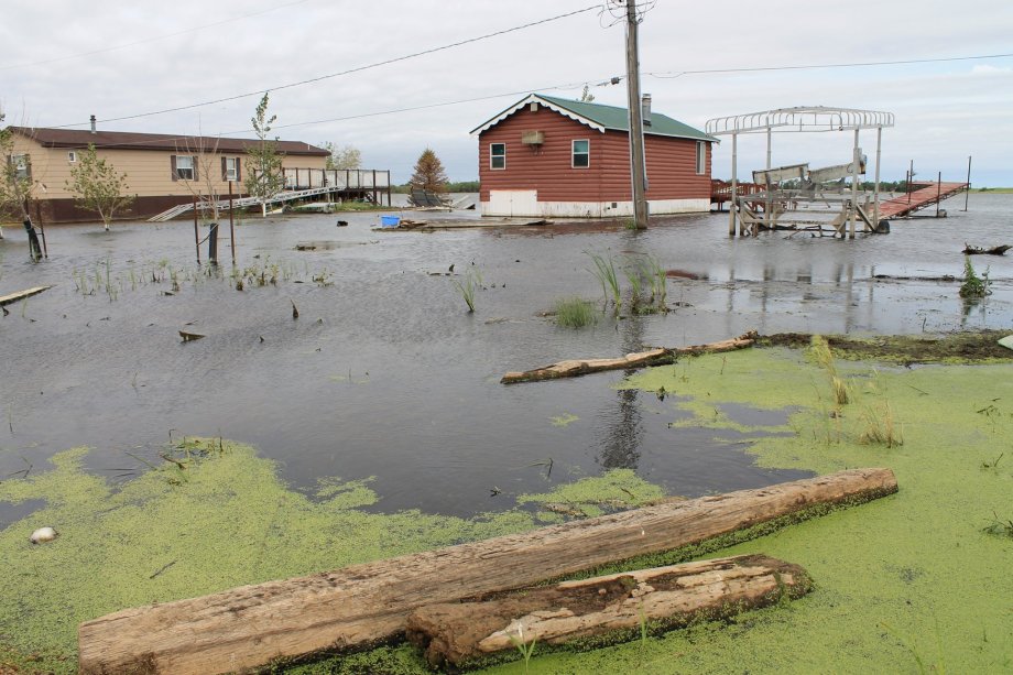
In 2020, the city of Waubay was in a crisis. Homes were underwater, and the city's sewer system was in shambles. Many had no plumbing or running water, and some had to abandon their homes and leave town due to the rising water.

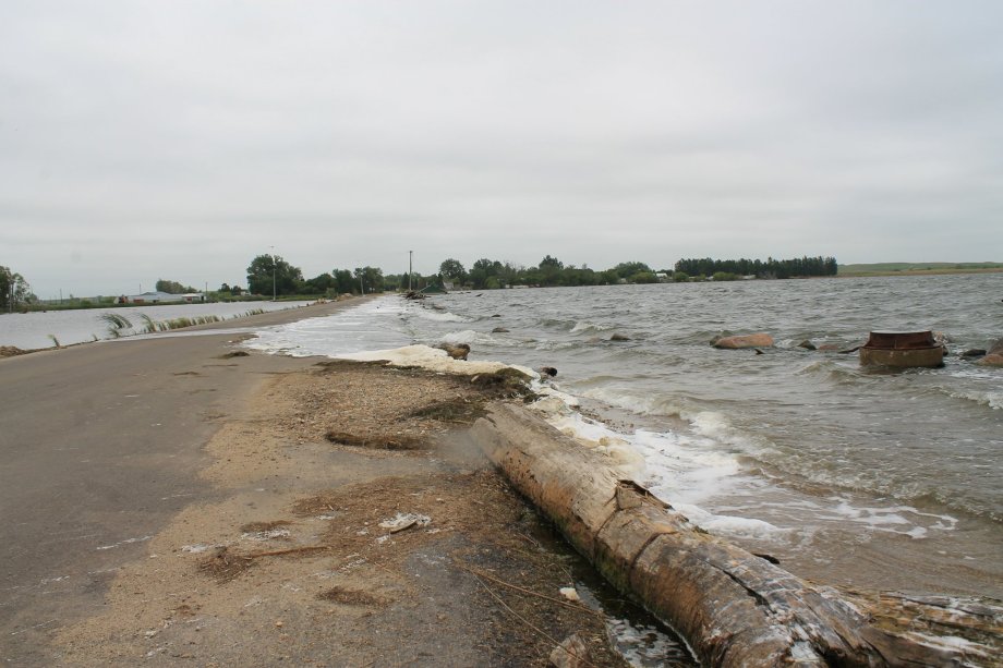
After two straight springs of extreme snow melt and heavy rain in northeastern South Dakota, Bitter Lake, a former slough on the southern edge of town, had increased dramatically in size, from 5 to 32 square miles in the past two decades, and had flooded out most of the shoreline properties. With few options, the city applied for and received a $1.6 million grant from the Federal Emergency Management Agency. Along with funds from the city and state, Waubay began a $2.2 million project to buy back the flooded lots that had become uninhabitable. This would allow homeowners to relocate and build new.
Many accepted the buyback offer, and the lots were cleared of the homes and any other structures. What should be done with the land now, Waubay officials wondered. With little guidance from the federal government, they decided to seek outside help.
Partnership with SDSU
During a water planning conference at South Dakota State University, Roger Johanning, Waubay's community planner, was listening to Jeremiah Bergstrom give a talk about flood-resilient landscapes. Bergstrom, a lecturer of landscape architecture in SDSU's School of Design, had significant experience working with flood-prone landscapes on the East Coast. He had been instrumental in helping New Jersey communities plan for flood protection following Hurricane Sandy. In the township of Woodbridge, where dozens of homes were underwater and had to be demolished, Bergstrom helped design and convert the otherwise vacant lots into flood protection zones.
Bergstrom could provide the exact guidance Waubay needed, Johanning thought.
Following the talk, Johanning approached Bergstrom to ask if he could assist them in determining what to do with the flooded, vacant properties that dotted the southern edge of Waubay. Bergstrom said he would take a look and made the 90-minute drive north to begin mapping out the properties. He was surprised by the severity of the flooding.
"They now have waterfront property that only a few years before were nearly a mile from the lake and open water," Bergstrom said. "When you see the pictures, it’s fairly dramatic how much the lakes have increased in size in a short amount of time."
Class project
During this time, Bergstrom was teaching an upper-level studio design class in SDSU's landscape architecture program. He determined Waubay would be a good opportunity to bring an experiential learning opportunity for community visioning and planning into the classroom for his students.
Due to the pandemic, students were unable to visit Waubay, but the class worked with the community to develop management strategies for properties purchased through the FEMA buyout.
"The students went through an exercise in visioning and generated ideas of what the possibilities for these empty lots and open spaces could be," Bergstrom said.
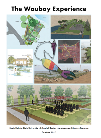
Some of the ideas included a wetland nature center, community gardens, a trail system and a public boat launch — all with an emphasis on reestablishing the natural environment to create more flood-resilient landscapes. The class created a document with all the ideas and explanations and submitted it to the city of Waubay.
"The goal of this planning effort was to provide the city of Waubay a series of unique visioning strategies and design concepts that could be used by the community to reimagine open space areas and invest in these new community assets," Bergstrom explained. "We hoped this could inform a dialogue among Waubay residents about the potential development and enhancement of these open space properties."
Bergstrom, who has been a licensed landscape architect for 20 years, realized that what happened in Waubay was happening all over the country. Hundreds of communities were dealing with changing, flood-prone landscapes and utilizing FEMA dollars to buy up the flooded-out lots. But they did not know what do with their now vacant, unused properties in the flood zone. The document made for Waubay could be reapplied and tweaked for communities across the country, he thought.
"There really isn't any information or guidance out there about what to do with these properties," Bergstrom said.
After reaching out to his former colleagues at Rutgers University in New Jersey, Bergstrom figured that all their collective knowledge and experience gained over the years could be applied, and used, around the country.
"We've been learning a lot, so I said, 'Let's take the information that we learned and get that out to the public,'" Bergstrom said.
Guidance for post-flood recovery
Waubay's story is not unique. Across the country, hundreds of communities have been affected by rising water and severe flood events. Flood-related buyouts have become quite common but, as Bergstrom explains, there is little guidance on what to do next, especially as they are often deed-restricted and suffer from past development.
"They usually must be maintained as open space, adding another challenge for local officials and maintenance staff," Bergstrom said. "These challenges can be managed by creating green infrastructure assets through an ecological-centered landscape restoration approach that combines principles of engineering, ecology and landscape architecture, which we outline in this document."
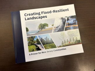
SDSU's School of Design, in conjunction with Rutgers Climate and Energy Institute, developed a first-of-its-kind guide for creating flood-resilient landscapes to help provide some guidance.
"This guidance document is aimed at assisting municipal leaders, technical professionals and other stakeholders in restoring ecological function to flood-prone landscapes as they work to make their communities more resilient," Bergstrom said.
Titled "Creating Flood-Resilient Landscapes A Primer for New Jersey Communities," the document is specific to New Jersey but applies to communities across North America.
The guide required a multidisciplinary approach.
“The challenge in developing this guide was conveying a variety of complex concepts to a very broad audience," Bergstrom said. "We needed to not only write about what we have learned but also illustrate it in a variety of ways.”
Contributing to the guide were former SDSU students Shelbie Smith, Emma Martin and Alyssa Faber. Smith, a graphic designer, designed the publication. Faber, a landscape architecture major, created many of the illustrations in the publication, and Martin, a community and regional planning major, helped research and outline the document.
"In reality, the principles and guidance that are set forth are applicable to any community that is wrestling with this issue of trying to reimagine these flood-prone areas that can no longer be used for homes and roads," Bergstrom said. "The principles and approach are applicable anywhere."
The situation is similar, regardless of the city or state. A flood event damages a property or neighborhood to the point it becomes unusable. Maybe it’s from repeated flooding events — like in Waubay — or one extremely damaging event — like in New Jersey. Regardless, these properties can no longer function in a residential area. FEMA buyouts remove the structures and transfer the property to the local community, and officials are left wondering what to do. This is when Bergstrom and his colleagues’ expertise comes in: they help find solutions to restore the function of this flood-prone landscape.
"We need to teach people and show people how they can take these landscapes and recreate them as highly functioning assets to their community," Bergstrom said. "When you take homes away, it leaves gaps in neighborhoods and communities and it looks like you’ve lost the battle, which is not true. These areas are now a vital part of a community’s infrastructure. They are green infrastructure."
The options for these vacant spaces are endless. Some may be used for trails, some may be restored to natural wetlands, and some are used for other forms of passive recreation. The guide also recommends reintroducing native plant species.
"How do we restore the flood-plain function, how do we increase the value of these landscapes for habitat and protection against future flooding, while also providing opportunities for passive recreation?" Bergstrom said. "We're trying to increase the land's ability to recover after flooding."
While the guide is primarily focused on the aftermath of flooded-out properties, Bergstrom notes that future construction should consider the effects that water, and potential flooding events, may have on homes and property.
"We need to think differently about water as we are building so that we minimize impacts on our neighbors and downstream communities," Bergstrom said. "We need these green infrastructure assets in our communities."
- Contact:
- Telephone number: 605-688-6161
Republishing
You may republish SDSU News Center articles for free, online or in print. Questions? Contact us at sdsu.news@sdstate.edu or 605-688-6161.