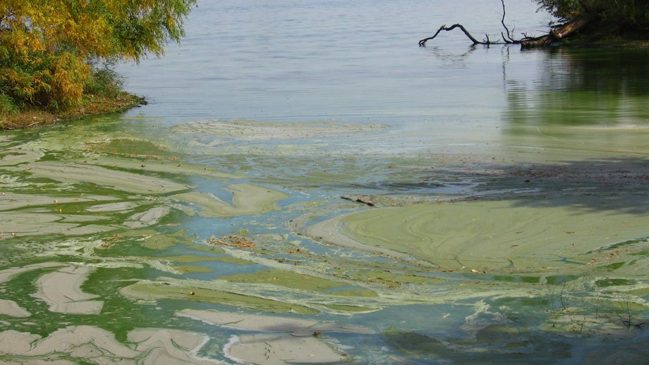
Lake Mitchell has a long history of algal blooms.
The reservoir, built in 1928, was once a source of drinking water for the city of Mitchell and recreation for the community. However, by the 1990s, algal blooms increased due to nutrients accumulating in the lake. By 2003, the city stopped using the lake as its sole source for drinking water.
Part of the problem is that the 350,000-acre Firesteel Creek Watershed drains into the 693-acre lake. “A 40:1 radio of watershed acres to lake area can be problematic—the ratio for Lake Mitchell is 500 to 1,” explained Paula Mazzer, an assistant professor of chemistry at Dakota Wesleyan University and board member of the newly organized nonprofit, Friends of Firesteel Creek. Mazzer described ongoing collaborative projects to address the problem at the October 2020 virtual Eastern South Dakota Water Conference.
“Upstream producers have taken advantage of state and federal opportunities to improve runoff, so each individual producer is contributing very little,” said Mazzer, estimating spring runoff is down to 0.14 to 0.26 pounds of phosphorus per acre per year. “That’s not too bad, but it’s such a huge watershed.”
Battling phosphorus
Additions of alum in 2003, 2004 and 2005 reduced the lake’s phosphorus levels to 600 parts per million. However, by the end of each summer, the lake had returned to its previous phosphorus level. During the last three years, the phosphorus level has been around 1,400 ppm. More than 100 ppm is severely eutropic, meaning there is not enough oxygen for aquatic life.
In 2015, a consulting firm found 47% of the phosphorus in the lake is trapped in the sediment, known as internal loading. Furthermore, an analysis of the sediment showed that “instead of iron III, which traps phosphorus well, up to 17% of the phosphorus is bound to iron II, which releases phosphorus easily,” she explained. “As soon as the phosphorus level in the lake starts to drop, the iron II releases phosphorus.”
Last year’s lower flow levels resulted in decreased phosphorus levels on the upstream input to the lake after mid-June, but the levels in the center of the reservoir and at the spillway rebounded, reflecting the high internal loading.
Building wetlands
A recent engineering study recommended creating wetlands to capture nutrients and dredging the lake as well as continuing watershed conservation efforts. The Friends of the Firesteel Creek nonprofit is working with the city of Mitchell and other organizations “to implement a version of this plan,” Mazzer said. That includes raising funds for the work that needs to be done and providing information to help people understand how these projects can help restore the lake. More information on the nonprofit.
In January 2019, Mitchell purchased 371 acres of land to build wetlands upstream of the Highway 406 bridge. The city has also applied for a $5 million National American Wetlands Conservation Act grant to support the project, according to a Feb. 25 Mitchell Daily Republic article.
In May 2019, a senior design team from South Dakota State University’s Department of Agricultural and Biosystems Engineering recommended building a low-head dam to prevent sediment and phosphorus from entering the lake. The city is now working with the U.S. Department of Agriculture Natural Resources Conservation Service, Ducks Unlimited, Pheasants Forever and the James River Water Development District to construct the dam.
SDSU Extension Water Resources Field Specialist David Kringen said, “A low-head dam will spread the water across the property, decrease flow velocity and allow for sediment deposition before reaching Lake Mitchell. The team also recommended that a multistage riser be incorporated into the dam to help manage flow rates.” Rather than water simply flowing over the top of the dam, the risers will allow water to flow through the dam at various stages.
Monitoring algal growth
Other SDSU faculty are doing research to connect the amount of algae with other water quality parameters, according to assistant professor John McMaine, who now leads the project. “We want to be able to monitor the extent of algae and blue-green algae concentration using a list of variables, including dissolved oxygen, temperature, turbidity, fluorescent dissolved, organic matter and nutrient levels.”
The project was begun by former assistant professor Rachel McDaniel, now an adjunct faculty member, and also involves biology and microbiology professor Bruce Bleakley. The research is funded by the U.S. Geological Survey 104B Small Grants Program administered through the South Dakota Water Resources Institute and an in-kind department salary match.
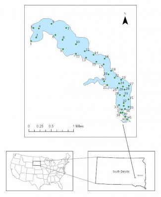
Last summer, SDSU researchers collected data at an average of 70 locations within the lake five times between July and October. That data will allow them to understand how the measured water quality parameters are changing through four dimensions: spatially across the lake, within the water column, and over time. Master’s student Sumit Kumar Ghosh is working on this part of the project.
In addition, McMaine and the team are trying to tie the measured chlorophyll-a data to remote sensing data from the European Space Agency’s Sentinel 2 satellite, launched in 2015, which has spatial resolution of 10 to 20 meters, depending on the spectral band.
“Instead of going out in a boat, you can use remotely sensed data to track algal blooms through time,” McMaine explained. “It will be a cost-effective tool that gives a more complete picture of the extent of algal blooms in the lake.” This tool will also help monitor the impact mitigation efforts, such as the wetlands and dam, are having on algal growth that will then improve the lake’s water quality.
Republishing
You may republish SDSU News Center articles for free, online or in print. Questions? Contact us at sdsu.news@sdstate.edu or 605-688-6161.