The SDSU IP Lab provides rudimentary geometric accuracy verification for sensor systems using our set of ground control points (GCPs) located in and around Brookings, SD. For this type of calibration work, the customer provides us with imagery centered on Brookings, SD, using his or her sensor. Our staff measures how close the corresponding geolocated pixel in the image is to our calibrated GCPs. We record these data for approximately 50 GCPS and from that data find the Circular Error 90% (CE90) and the Root Mean Square Error (RMSE) which are measures of the average error in horizontal distance from where the satellite indicated it was pointed and where it was actually pointed when it imaged our site. These results allow the customer to determine if there is a systematic pointing error with his or her system or internal location errors in the sensor. An example of the output data produced from this work is shown in Figure 5.
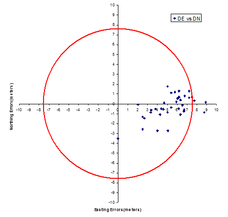
Figure 5 shows an example of the output provided to customers for Geometric Calibration. The plot shows the offset in the northing and easting directions for Ground Control Points (GCPs) at the Brookings, SD site recorded by this sensor. It can be seen that there is a systematic error of approximately 5 meters in the easting component. However, the red circle denotes the specification for the sensor in terms of CE90 which specifies that 90% of the GCPs must lie within that circle. Hence, the customer can readily determine if his or her sensor is meeting specifications with this information.